Lines drawn by the land and its watersheds
By Bay Stephens
EBS Staff Writer
Dubbed the “Arid Lands” by John Wesley Powell, the American West and its pervasive brown tint dismayed settlers as they moved from fertile eastern states to stake claims in the American frontier. Powell, the iconic, one-handed and self-taught geologist, professor, pioneer and statesman, recognized that water would be the limiting factor in western American development.
Powell sought to organize the sprouting communities in a way that united them around the scarce resource, which would have yielded a very different West than the one that we know today.
According to Dr. Mark Fiege, an environmental historian at Montana State University, the Land Ordinance of 1792 had sectioned the unsurveyed land in the western U.S. into square-mile tracts, or 640-acre parcels. Nearly a century later, the Homestead Act of 1862 and subsequent acts mobilized waves of settlers to the West, granting 160-acre parcels—a quarter of a square mile—to homesteaders with the promise of ownership.
In “Seeing Things Whole,” a collection of Powell’s writings, editor William deBuys writes that “the act guaranteed suffering and sorrow by encouraging people to stake their all on a gamble they were sure to lose,” as less than 20 inches of annual rainfall in the Arid Lands wouldn’t produce a marketable crop. Irrigation was essential to agriculture, but stream flows were diverted until they ran dry, and settlers were often pitted against one another to get enough water to their land.
Unless settlement patterns changed, Powell knew that contention over water would be the heritage of the West. “Powell was a realist when it came to appraising the environmental capacities of the mostly arid West,” Fiege said. Powell saw another way.
During his extensive travels throughout the West, Powell encountered collectivist communities such as the Mormons in Utah and Hispanic villages at the base of Colorado’s Sangre De Cristo Mountains, whose collaborative land management impressed him.
The system employed by the Hispanic villages involved a communal tract of optimally located farmland near the valley floor. A large irrigation ditch—an “acequía madre”—brought water from mountain streams to the farmland, forking into smaller acequías to reach individual plots. Plots were cultivated by separate families but not owned in the way that we define ownership today, Fiege said.
An “ejido”—Spanish for “common land”—surrounded the town and fields, and was unfit for agriculture, used instead as pasturage and timberland.
“You can see there is already imbedded in these lands a notion of collective or communal ownership and operation,” Fiege said. Powell just wanted to scale it up.
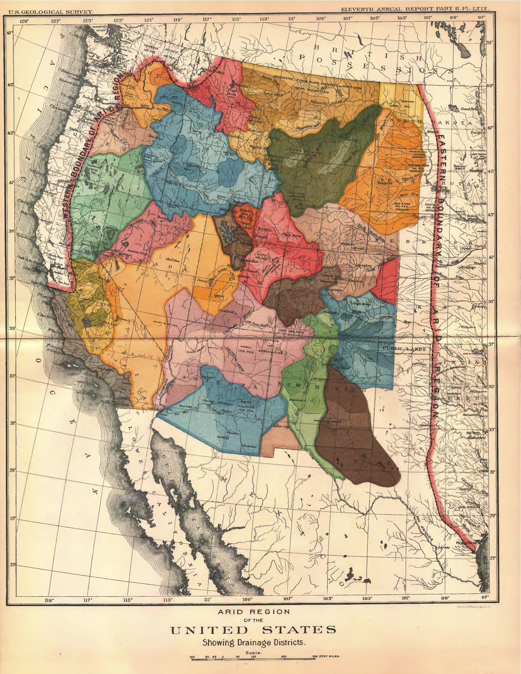
He proposed dividing the West into water districts based on hydrographic basins, where those that lived in areas where the waters flowed into the same stream would be members of the same district. The federal government would initially conduct geographic and hydrological surveys to determine boundaries between districts, water volumes caught in each, and lands that could be sustainably cultivated with these waters.
It was a “[a structure] of local government [designed] to nurture the growth of communities in balance with the capacity of the land,” deBuys writes.
Under Powell’s system, the government wouldn’t allow water caught in one hydrographic district to be used in another, or on land not designated as irrigable. That would be the extent of federal involvement, however.
“[Powell] believed that once the central government had established fair rules for economic and social interaction, it should get out of the way,” deBuys writes. It would be the responsibility of the people to govern themselves and their own water usage going forward, making decisions from the perspective of a community with shared interests.
Powell envisioned as many as 150 such commonwealths spread throughout the West. They would function similarly to county districts except the lines would be drawn by the land. Had Powell’s proposals been implemented, the Gallatin-Madison county line wouldn’t split Big Sky in half and satellite images of the western United States wouldn’t reveal sprawling grids of farmland. Some of these watershed commonwealths would straddle two or even three states.
However, by the time Powell presented the most robust version of his idea to the U.S. House of Representatives committee on irrigation around 1890, an array of cultural, historical and political challenges caused Powell’s vision to go unheeded.
It’s difficult to know whether these districts would have been successful. deBuys discusses how, with 150 separate districts, there would have been “150 separate experiments” and as many different outcomes. The functioning of each district would be distinct from any other by virtue of disparate landscapes and watersheds and individuals. Some outcomes may have been little different from what happened in the water-starved West. Others could have exceeded the best of Powell’s hopes for a cooperative agrarian community.
“We will never know,” deBuys writes, “All we can be sure of is that the variety of results would have been greater than that which the Arid Lands have thus far known.”