


By Isabel Hicks, MSU NEWS SERVICE
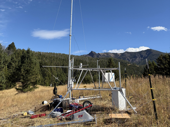
Researchers at Montana State University are collaborating with NASA’s Western Water Action Office and the city of Bozeman to refine a first-of-its-kind weather monitoring station at the headwaters of Bozeman Creek. The hydrometeorological station, which started operating this fall, will provide critical data for the city’s long-term water resource planning and drought management strategy.
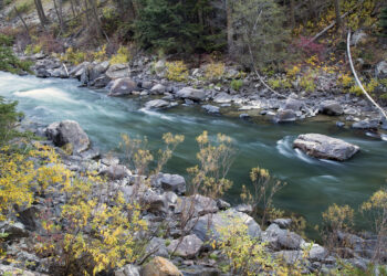
The station is installed at the start of Bozeman Creek, sometimes called Sourdough Creek, located a few miles past Mystic Lake on a city-owned plot within the Custer Gallatin National Forest. Bozeman Creek provides about 40% of the city’s water supply – the rest comes from Hyalite Creek in the Gallatin Range and Lyman Spring in the Bridger Range – but Bozeman has not had a station to take snowpack and other measurements there until now.

Snowpack levels are the main determinant of water supply in the Rocky Mountain West, said Eric Sproles, associate professor of Earth Sciences and director of the Geospatial Core Facilityat MSU, who led the station’s installation. Snow in the mountains melts to recharge groundwater and feed streams and rivers at lower elevations, he explained, ideally at a gradual rate through spring and summer. But when snowpack becomes more variable, or changing temperatures cause melt to happen earlier or faster, the timing and amount of water supply shift.
The Bozeman Creek station is equipped to measure snow depth, snow water equivalent, precipitation amount, temperature, wind speed and direction, relative humidity, pressure, and solar radiation. Its additional sensors complement nearby SNOTEL stations operated by the Montana Natural Resource Conservation Service, Sproles said, which is a huge boon for MSU researchers and NASA collaborators.
“These will be measurements that we can use to calculate how much water is being stored in the snowpack, and also how fast it is melting,” he said.
NASA provided MSU $100,000 for the project because the station lies in a high-repeat orbit area for its newest flagship satellite, NISAR, Sproles said. MSU will compare its own data to that of the satellite – which uses radar waves to see within the snowpack and measure its properties – to help NASA vet and refine the satellite’s accuracy.
The city government spent approximately $30,000 to pay for the equipment. Bozeman had been planning to install monitoring capacity in the Bozeman Creek watershed for a while, said Jessica Ahlstrom, the city’s water conservation program manager. Based on Sproles’ expertise and interest, it made sense to collaborate.
“It’s really a win-win,” Ahlstrom said. “MSU gets instrumentation to support their research goals, and the city gets additional data to help inform its water resource planning efforts.”
The data will be useful for the city’s drought management efforts, which implements certain water restrictions as needed based on worsening drought conditions, and the long-term integrated water resource plan, which looks ahead 50 years to account for future water supply needs, Ahlstrom said. Overall, the station will provide a more complete understanding than the city has had before of the timing of the snowmelt and how that is shifting, she said.
“It’s a special type of project. We couldn’t just hire a contractor or have some staff go up there and install it,” Ahlstrom said. “Having MSU’s expertise and really understanding the equipment, what it does, where it should be, how it should all be set up is really important.”
In 2020, the Montana Climate Office out of the University of Montana received a $21 million U.S. Army Corps of Engineers grant to install hydrometeorological stations across the state, mostly in farmland. The Bozeman Creek station is a replicate of those state-of-the-art stations already working in Montana, just at a higher elevation, according to Sproles.
“This isn’t just going to be a station that’s set up and feeding raw data to the city. MSU has the capacity and expertise to really use the equipment to ask and answer bigger questions about the interplay of climate and snowpack in our watershed,” Ahlstrom said.
Several students volunteered to help out Sproles with the install, including senior snow science major Sam Pruitt. From Asheville, North Carolina, Pruitt participated in an internship last summer with the Henry’s Fork Foundation in Idaho where he helped install similar snow monitoring stations across the Upper Snake River watershed.
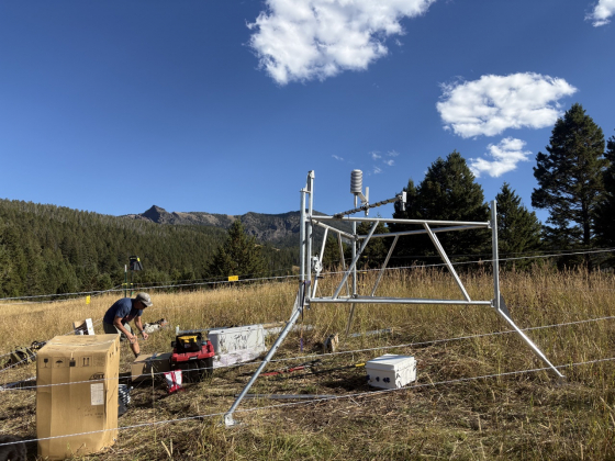
Pruitt traveled to the Bozeman Creek headwaters three times this fall. A four-wheel drive vehicle can only get so far up the dirt road, and then people carried the heavy equipment – including large metal poles, sensors and solar panels – for 2 miles, he said. Pruitt helped drill anchors into the ground for station stability, bolted pieces together, and learned to troubleshoot an issue with a sensor. The sensors are connected to a Starlink satellite and include a LIDAR camera and instruments that help scientists calculate the amount of water content within the snowpack.
Pruitt said the project is helping familiarize him with the technology and build the skillset needed to work as a snow scientist after graduation. He will also use it in a research capacity: Pruitt recently submitted a proposal for an independent study to validate the sensors are working this spring. Doing the study will allow Pruitt to finish his minor in Geographic Informational Science, or GIS.
“We absolutely anticipate that there will be research coming out of this in the future. There is a 100% chance that students will use this for their graduate research,” Sproles said. The area’s snowpack is especially important because it feeds the headwaters of the Missouri River, he added.
Other MSU faculty in the Department of Earth Sciences and the Department of Land Resources and Environmental Sciences who partnered with Sproles on the NASA grant and may use the station for future research include Marianne Cowherd, Tim Covino, John Knowles and Erich Schreier.
“It’s not just one little watershed,” Sproles said. “It’s a watershed that we can learn so much from and really leverage that information to improve science that will improve water management in the West.”