Chris Boyer’s aerial photography marries art and science
By Bella Butler EBS STAFF
LINCOLN – In his essay “Two Minds,” author Wendell Berry suggests there are two types of human minds, what he calls the “Rational Mind” and the “Sympathetic Mind.” The Rational Mind is that which is mobilized by facts and operates analytically—some might call it the mind of science. The Sympathetic Mind, Berry writes, refutes a reality composed only of reason and objectivity; it is loving.
Hundreds of feet in the air, in a 1956 Cessna 172 airplane the color of a candy apple, Chris Boyer exempts himself from the dichotomized nature of the science and art worlds—or what Berry might label the Rational and Sympathetic.

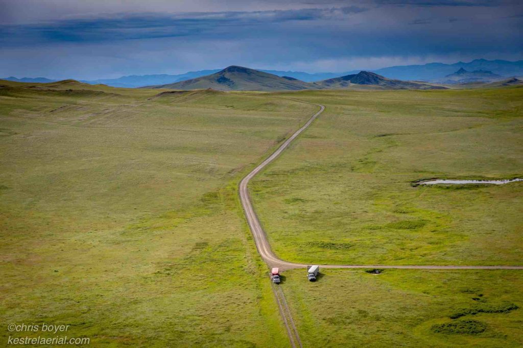
Boyer is the owner of Kestrel Aerial Services, a documentary photography and survey mapping company. His vessel, which he simply calls the Red Plane, is equipped with a vibration-damped vertical camera mount that allows him to shoot wide-angle photos from the belly of the aircraft.
These photos and other information he gathers in flight are then used to create images and maps that provide intel on everything from the minutiae of a landscape like plant and wildlife communities and habitats to broader contextual material related to land use and other pertinent issues.

At the Bozeman Yellowstone International Airport, where Boyer keeps the Red Plane at a private hangar, he pumps the throttle three times. “Clear!” he shouts over the harmonious whizzing of the propeller and engine. He waits his turn on the runway before directing the plane onward and upward. His takeoff is smooth, well rehearsed.
Boyer started flying planes during graduate school at Oregon State University, where he challenged his former East Coast liberal arts degree by studying hydrology, political science and fluvial geomorphology—the study of the physical shape of rivers, sediment transport and the resulting landscapes. In an attempt to put the involuntary student activity fee to work, he joined the flight club and learned how to be a pilot. As an abstract learner, Boyer said he is convinced that the visual interpretation of the landscape flying afforded him got him through tedious graduate math classes.
“The aerial view was just as important at teaching me river process as the complex math I learned in the classroom,” Boyer wrote in an email to EBS.
While Boyer was at OSU, Geographic Information Systems mapping also was taking off. Digital creations conveyed variations in landscape using colors, symbols and shading. “We got into such a race to abstract and simplify and symbolize the landscape that we kind of forgot what it actually looked like,” Boyer told me in the front seat of the Red Plane on a hazy July morning. This detached way of viewing the earth was a reflection of the flaws Boyer had discerned within the scientific world.

“Science has always had that issue that anything that is not quantitative should not be relevant,” he said. While necessary and purposeful, Boyer explained, the stiff expression of data acted as a filter for emotions, for humanness. Just as Wendell Berry argues that the Rational Mind creates a much narrower view of the world than what actually exists, Boyer believes that “landscapes as a manifestation of orderly data” are too small a format to capture the wholeness of rich systematic ecosystems.
“I feel like you’re just missing the boat somehow if you’re not awed … by whatever landscape you’re working in; if you have to sort of filter out an emotional response to it,” he said. He pondered why lifeless figures were being used to tell the complex narratives of land and water. The landscape had appeared to Boyer as an array of stories, but to him they needed a better way to be told.
“We don’t suffer from a lack of data, we just suffer from a lack of good stories about the data,” he said, referencing a sentiment he’s shared in pitches and presentations for years, one that he found is nicely complimented by a Brené Brown quote: “Maybe stories are just data with soul.”
“The camera seemed to be such a natural way to tell that story,” he said.
Boyer always had an appreciation for visuals; he admitted you’ll find more sketches in his college notebooks than notes. When first embarking on his informal education in photography, he looked to “Family of Man,” Edward Steichen’s famous photography exhibition that first debuted at The Museum of Modern Art in 1955.
Boyer experienced an epiphanic moment when he realized that all the photos in the collection were familiar to him. The resonate power of the photographs had effectively taken root in his memory, a testimony to the withstanding impact of imagery.
He recalls the cathartic shift in tone when the photo of the Syrian child face down on the shore emerged on the front pages of newspapers around the globe. The conversation about refuges transformed from an abstract concept to a sympathetic and dire tragedy.
“It’s so easy to think of something as a statistic,” Boyer said. “If you don’t see its face, you can’t really learn its story.” Boyer hopes his photographs provide such a face for the landscape—that they offer a window into its character—but he wouldn’t be so bold as to say they accomplish this.
Pinched between the Mission and Cabinet mountains in the Swan Valley, Boyer flies the Red Plane over an imaginary grid above a conservation-based ranch near Condon, Montana. Each year, he maps a portion of the ranch to track swan populations and habitat.
Boyer says the maps he creates are tools that can be used for observing differential growth rates in crops, identifying plants and monitoring the condition of habitats. The conservation ranch uses Boyer’s swan maps to track responses to management year over year.
Boyer traces the grid lines like brush strokes, artfully gathering both quantitative and qualitative information that will later be displayed in compelling visual formats. In order to survey, the plane must be low and nimble. Boyer makes tight turns, flipping the plane on its side so that the Cabinet Range appears vertical through the front windshield.
The warped landscape and jarring movements instigate a nasty churning in my stomach, but Boyer is unperturbable. I spare myself from notetaking for a moment and attempt to take in the fleeting scenes moving in and out of the cockpit view, afraid I won’t be able to absorb each feature before returning to my small view of the world from the ground.
The camera, fixed into the floor, shoots photos in two-second intervals. In a former life, the hole where the camera lives held two inspection ports. When Boyer wanted to make the holes bigger, an engineer told him that the holes historically were occasionally enlarged so that newspapers could be delivered in rural areas. This allowed him to get a field approval from the Federal Aviation Administration to make a bigger hole for his camera.
“I think the meanders of a river is one of the most beautiful shapes in nature,” Boyer remarks as we cruise over a stream cutting through a pasture of cows. He’s right—there’s something so inexplicably hypnotizing about the sweeping bends and breaks. From above, it’s easier to see how rivers command the landscape. Everything yields to the water, yet its movement is more maternal than patriarchal, a quieter, providing force.
“The plane offers a very different perspective of nature and ecosystems,” he wrote during one of our email exchanges. “[It] highlights the vastness and complexity which is inherently humbling … [It] gives you an opportunity to see the whole from far enough away that in some instances you aren’t reminded of the clutter of humanity.”
Boyer’s favorite work involves the conservation projects that share in his mission to employ emotion in science; to braid the Rational and Sympathetic minds, so to speak.
“[Imagery is] kind of an organizing structure around which you can drape complex information and recall it afterwards,” he said. “It gives the landscape a character.”
Existing at the sparsely inhabited intersection of art and science, Boyer’s work is meant for everyone, not just those partial to exclusive jargon. “Scientists forget that the reason they’re doing science is to manage it for all of us that don’t understand science, so you have to compel people to understand what your research is about,” he said.
In the present world of binaries, Boyer’s survey mapping and documentary photographs seek to mend the fissure between the pragmatic practice of data and statistics, and the interpretive and esoteric creations of an artist in order to compel laymen to compassion and understanding for the diverse landscapes of the West.
Berry wrote: “…the safe competence of human work extends no further, ever, than our ability to think and love at the same time.” From the Red Plane, statistics and lines overlay human experience and connection. Chris Boyer’s photos are a permissive gesture to both think and love the landscape and perhaps gain a humbling experience.