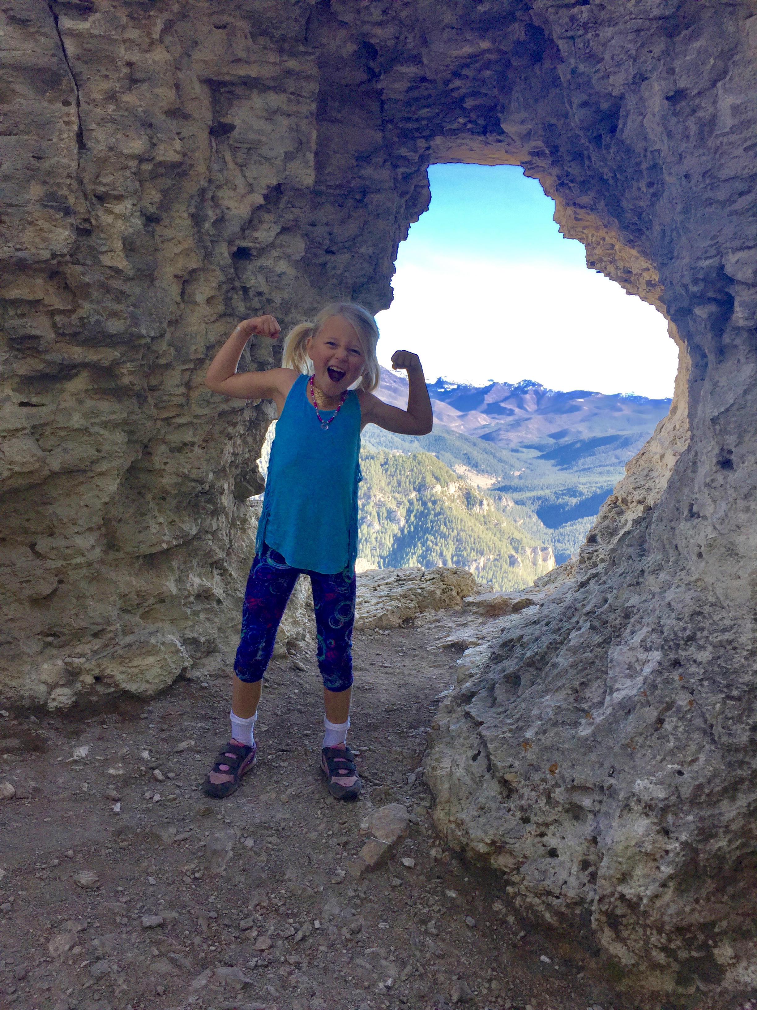
Hiking Storm Castle Peak Trail is a truly magical experience. Storm Castle is one of the more prominent geological features in Gallatin Canyon and this hike provides expansive views from it in a fairly short distance. This 4.7-mile hike allows you to summit and sit atop one of the most breathtaking rock outcrops in this area. Novices and experienced hikers alike can feel like they’re top of the world while sitting on this iconic limestone monolith overlooking Gallatin River and the surrounding mountains.
Storm Castle Peak Trail is an intermediate hike with a hefty 2.35-mile climb on a narrow natural-surface trail. Although the elevation gain is significant, the consistent grade and switchbacks interspersed with incredible vistas throughout make for a pleasurable experience for individuals of all abilities.

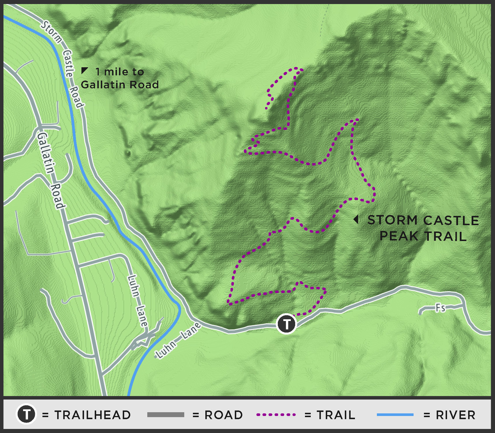
Start at the Forest Service trailhead parking lot located on the north side of Storm Castle Road. While hiking up meandering switchbacks and through a beautiful “enchanted forest,” you’ll have several options for water and snack breaks on small outcrops with big vistas. The closer you get to Storm Castle Peak, the more side trails have been cut in. Stay on route and prevent erosion by following the most prevalent trail.
Once the rock itself is in sight, the route will wrap behind Storm Castle and then climb to the top of it. There are several areas at the top where you can sit and admire the distance you have climbed. Make sure to save some energy for the 2.35-mile hike down—it goes fast, but it can be challenging with steep switchbacks and loose rocks. Also make sure to choose safe places to pass other hikers and be conscious of your dogs or children kicking rocks onto hikers below you.
Fall is an excellent time for Storm Castle Peak Trail, however I don’t recommended hiking it in slick conditions due to its grade and tight turns. This was my daughter’s first big hike and summit. The confidence and pride she found on top will hopefully cultivate a lifetime of recreation and appreciation for the world around us. I encourage you to go explore, test your limits, and bask in the feelings of gratitude that this hike provides due to its majestic nature.
For more information about Big Sky’s parks, trails and recreation programs, visit bscomt.org. The Big Sky Community Organization is a local nonprofit that connects people to recreational opportunities by acquiring, promoting and preserving sustainable places and programs for all.
 Trail stats
Distance: 4.7 miles roundtrip
Difficulty: intermediate
Elevation gain: 1,880 ft
Surface: dirt
Uses: hike
Directions: From Big Sky, drive north on Highway 191 for 17.2 miles. After passing the Lava Lake Trailhead, turn right onto Storm Castle Road, a well-maintained dirt road. Drive about 2 miles until you approach a small row of parking spaces on the north side of the road marked with a Forest Service trailhead sign.