Data show rivers have been receding faster than average, raising concerns about late-season flows.
By Carli Johnson STAFF WRITER
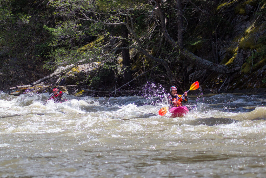
Spring in Montana doesn’t leave much to be desired—all activities are a go. For those who can’t stow away the skis quite yet, there’s always the chance of a late storm to bring in a few more inches of snow. And for those itching to get on the rivers, there’s usually enough snowmelt to find their fix.
This year, however, early indicators suggest the Gallatin and Yellowstone rivers could see below-normal flows later this summer.

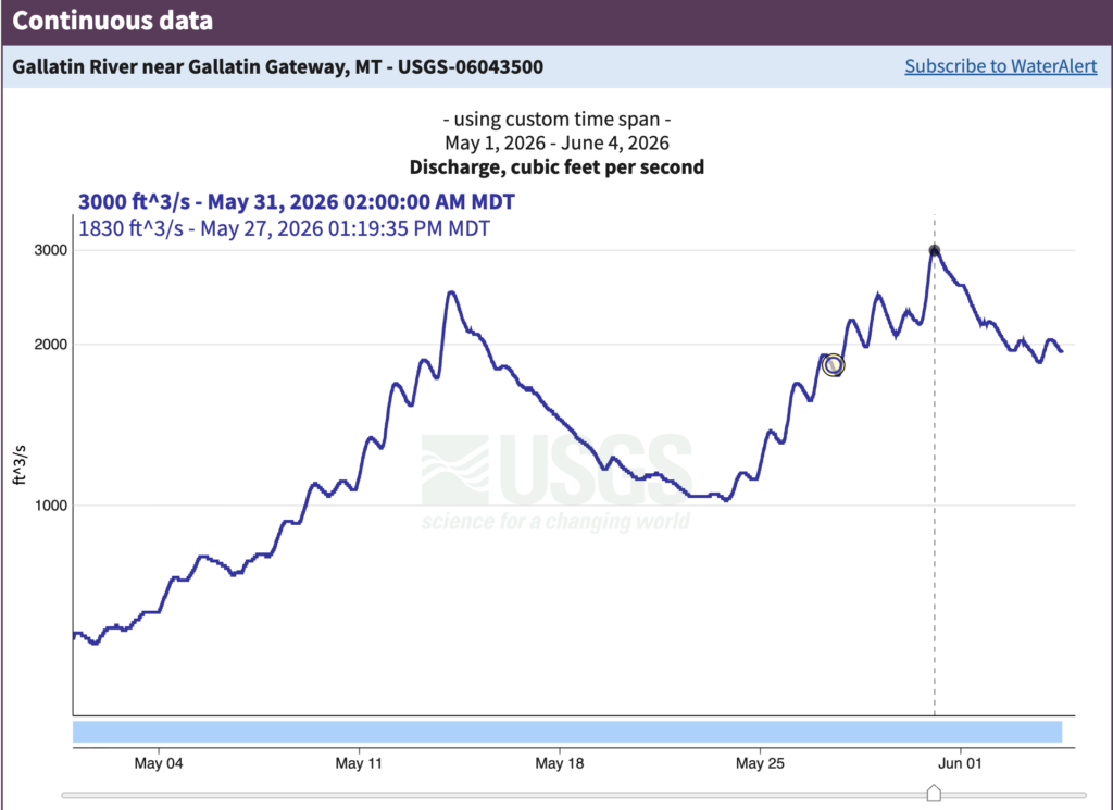
Snowpack at the Lone Mountain mid-mountain SNOTEL site is already gone, roughly two weeks ahead of the typical date, according to Kristin Gardner, chief executive and science officer at the Gallatin River Task Force. Peak runoff on the Gallatin has already occurred, and Gardner said the 2026 peak ranks among the lowest in recent years.
“Projecting from the current moment, things can change,” Gardner said. “There’s likely to be lower than normal flows if we have a hot summer. All that can change, though, if we have a wet summer.”
The most likely scenario, Gardner said, is a summer marked by lower river flows and warmer water temperatures—conditions similar to, or potentially more pronounced than, those experienced last year.
The Natural Resources Conservation Service tracks snow-water equivalent—the amount of water contained in the snowpack—at monitoring stations across western mountain ranges throughout winter and spring. Those figures are used to forecast how much water will eventually reach rivers during runoff season.
“When a snowpack is shallow, it does tend to produce this kind of fast rise and steep fall,” Gardner said. “There’s simply less water stored in the mountains to release gradually over time.”
Last year’s runoff season offers a glimpse of what can happen when that pattern plays out.
A review of streamflow data maintained by the U.S. Geological Survey shows that while the Gallatin and Yellowstone rivers have been peaking near or above historically normal flow volumes in recent years, both rivers have been losing water significantly faster than average in the weeks that follow those peaks.
On June 2, 2025, the Gallatin River peaked at roughly 4,611 cubic feet per second—measured at the Gallatin Gateway gauge—slightly below its 30-year median peak of 5,250 cfs. The Yellowstone peaked the same day at 20,300 cfs, also slightly below its historical median of 22,950 cfs. Aside from flow volume, June 2 is the average date for the rivers’ peak.
At first glance, both rivers appeared relatively healthy at peak runoff last year.
What followed is where the season diverged from the historical record.
Within six weeks, the Gallatin had lost 84% of its peak flow. The Yellowstone had lost 82%. While snowmelt-driven rivers naturally decline after runoff season, the speed of the drop stood out.
By July 15, the Gallatin was running 25% below its historical median flow for that date. The Yellowstone was running 40% below.These steep recessions in river flow correspond with the gradual decline in snowpack observed across the region.
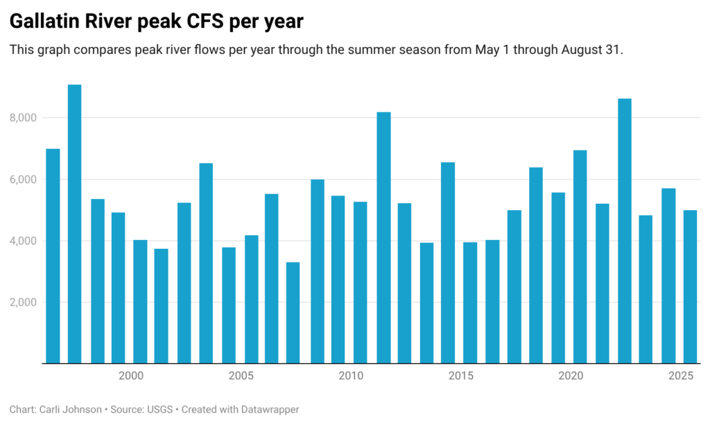
Notably, the Gallatin’s 2025 peak of 4,611 cfs ranks as the sixth-lowest peak recorded in the past century at the Gallatin Gateway gauge, according to Gardner, underscoring the dire 2026 peak of 3,000 cfs.
Three decades of context
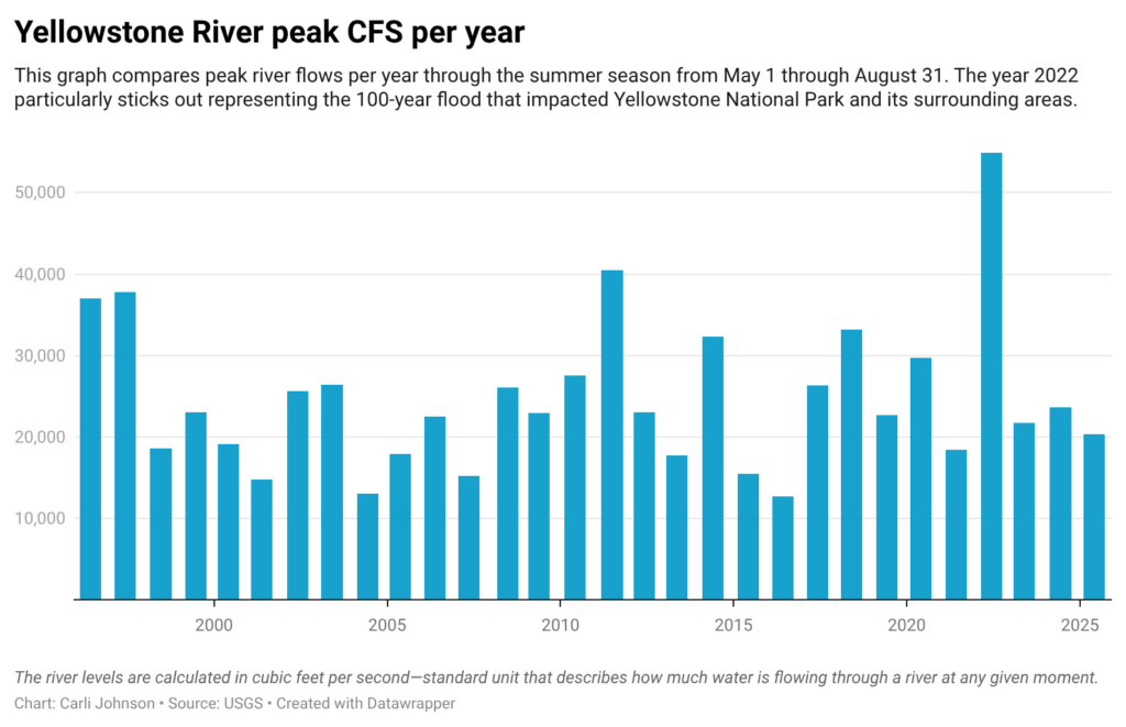
To understand where 2026 fits in the overall record, EBS reviewed daily flow data from USGS monitoring stations on both rivers for the period from 1997 through 2025.
The Gallatin River has run below its median peak in recent years. The lowest single-year peak in the dataset occurred in 2007, when the river reached just 3,034 cfs. That was followed by 2001 at 3,178 cfs.
On the Yellowstone, 2016 recorded the lowest peak in the 29-year dataset at 11,981 cfs, followed by 2004 at 12,299 cfs.
The long-term record shows that low-flow years are not unusual. What has drawn attention in recent seasons is how quickly rivers have been draining after peak runoff, leaving significantly less water available later in the summer.
For guides, anglers and irrigators whose summers depend on these rivers, streamflow data can translate directly into the length and quality of the season.
Lower stream flows and warmer water temperatures can contribute to algae blooms and deteriorating water quality. For anglers, the consequences can be even more immediate.
“When water temperatures get too warm, that’s when hoot owl restrictions come into play,” Gardner said.
Hoot owl restrictions are fishing closures designed to protect trout during the hottest parts of the day when water temperatures become stressful for fish. The upper Gallatin has never had a hoot owl restriction.
Whether that remains true this year may depend on how the summer unfolds.
Gardner said community awareness becomes especially important during low-water years, and that reducing pressure on rivers during periods of low flow can help protect river health when water is scarce.
———————————————————
About the data
The U.S. Geological Survey maintains stream gauges on rivers across the country, including on the Gallatin River near Gallatin Gateway and the Yellowstone River near Livingston. Those gauges continuously record streamflow, measuring the volume of water moving past a fixed point in cubic feet per second, or cfs.
For this story, daily mean flow readings from both stations were downloaded from the USGS National Water Information System for the period May 1 through Aug. 31, covering data from 1997 through June 1, 2026. Historical medians were calculated using data from 1997 through 2024.
Data source: U.S. Geological Survey National Water Information System, daily mean streamflow, USGS Station 06043500 (Gallatin River near Gallatin Gateway, MT) and USGS Station 06191500 (Yellowstone River near Corwin Springs, MT).
Snowpack data: Natural Resources Conservation Service SNOTEL network, Lone Mountain station.