A look at late season snow conditions
Story and photos by Eric Knoff Explore Big Sky Contributor
Spring skiing can be some of the best of the season. Good snow coverage, warmer weather and more predictable snow stability – at times – can lead to unmatched conditions. But spring can also hold avalanche hazards not encountered during the colder days of winter.
As snowpack and weather transition into warmer and wetter patterns, there are a number of variables to pay attention to.

Two factors that influence stability are terrain and aspect. Typically, loose, wet avalanches occur earlier in spring days on southerly aspects due to the impact of solar radiation. This type of instability then moves to east-, west- and potentially north-facing slopes as the day progresses.
Using different aspects to your advantage is a great way to enjoy spring riding conditions and avoid rising instability. However, changing aspect isn’t always a surefire way to avoid unstable conditions. Numerous other factors influence snowpack stability in springtime.
One significant factor is temperature. As temps warm above freezing, surface layers of the snowpack begin to melt. If temperatures drop below freezing, this process is slowed, allowing the snowpack to adjust to these changes. However, a large influx of free-moving water can be introduced into the snowpack if temps stay above freezing for multiple days in a row. This can create widespread instability and dangerous avalanche conditions.
I typically don’t trust a snowpack that hasn’t experienced a freeze in the last 48 hours or longer. This is especially true if it’s the first time of the season the snowpack is enduring a prolonged period of above-freezing temperatures – both day and night. I also don’t trust wet snow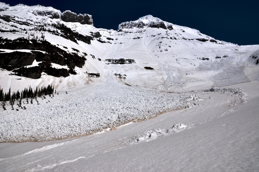 that’s deeper than my boot top, which is a clear indicator that surface conditions are becoming unstable and wet-snow avalanches are likely in steep terrain.
If temperatures stay above freezing for an extended period of time, the snowpack can become isothermal – when the entire snowpack reaches 32 F. In isothermal conditions, the structural integrity of the pack begins to break down, making wet-snow avalanches likely. Typically during spring skiing, it’s best to get an early start when the snowpack is frozen and stable, and be off the slopes by the heat of the day.
The season’s snowpack structure also plays a significant role in springtime avalanche danger. A major contributing factor to springtime avalanches, particularly wet-slab avalanches, is the presence of buried, persistent weak layers. PWLs include depth hoar, surface hoar and near-surface facets. The presence of PWLs can produce dangerous conditions months after these layers form and are buried. Depth hoar, or faceted snow near the ground, is the most notorious weak layer for producing large wet-slab avalanches.
Fortunately, none of these PWLs exist in the snowpack this spring, mainly due to the region’s above-average temperatures and below-average precipitation this winter. PWLs are formed under strong temperature gradients, which are typically created during long cold snaps. Without prolonged periods of cold weather, the snowpack wasn’t plagued by buried, persistent weak layers.
But springtime avalanches still occur without buried PWLs. A common problem during warm spring weather is wet, loose avalanches, or sluffs. This form of avalanche is typically less dangerous than wet slabs. However, sluffs can entrain large volumes of snow capable of carrying and sometimes burying a skier or rider.
Wet sluffs generally start at a single point, but fan out as they move downhill. In steep terrain, these avalanches
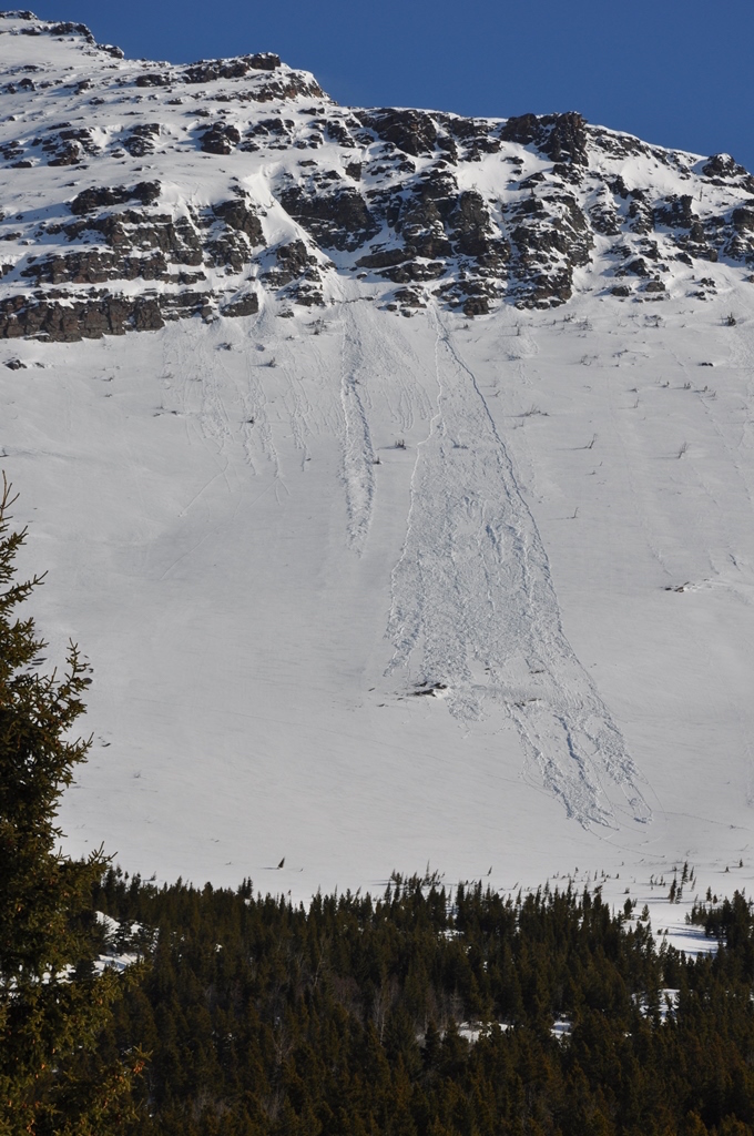 can travel long distances and pick up significant volume and speed. During the right conditions, this type of avalanche can travel into lower angle or flat terrain, and you must be aware of your terrain selection when traveling beneath avalanche-prone slopes.
Wet-snow avalanches in spring typically occur during prolonged periods of warm and dry weather. This is generally the opposite of mid-winter avalanches, which tend to occur after periods of heavy snowfall.
If you’re planning on spring riding, pay attention to changing snowpack and weather conditions. Staying current on snowpack structure and temperature fluctuations is the best way to stay on top of – rather than being buried under – the snow during the spring riding season.
Eric Knoff is an avalanche forecaster for the Gallatin National Forest Avalanche Center. He’s been a public forecaster for the past six years, and an avalanche forecaster during the Going-to-the-Sun Road plowing operation in Glacier National Park the past four springs.